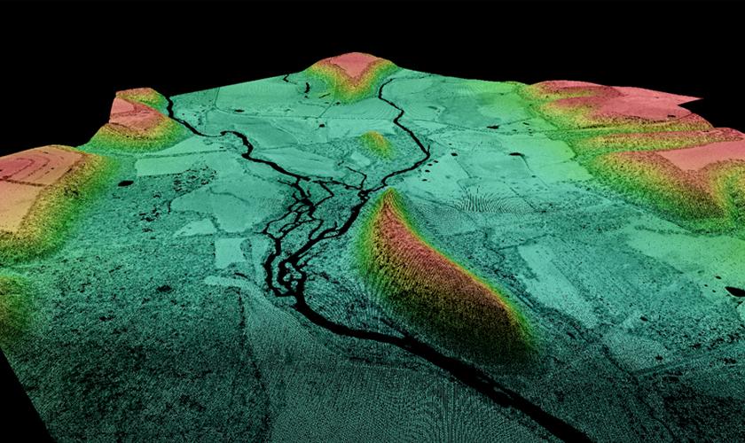
 LiDAR point cloud colorized by elevation and intensity, showing only bare ground points.
Light Detection and Ranging (LiDAR) involves a light beam that measures and maps the earth's surface. Over the last two decades, LiDAR technology has grown by leaps and bounds, with LiDAR data collected from a variety of platforms such as helicopters, ground-based vehicles (Mobile Terrestrial LiDAR Scanning), and tripods (Stationary Terrestrial LiDAR Scanning). With the growing variety of LiDAR acquisition options, it can be challenging to understand the purpose and limits of each type of acquisition method. This article addresses the realistic expectations for an aerial LiDAR dataset acquired from a fixed-wing platform.
Project Planning
When planning an aerial LiDAR project, it is important to remember that LiDAR collected from a fixed-wing aircraft can reasonably be expected to provide accuracies sufficient for the generation of 2’ contours with minimal breakline addition, or the generation of 1’ contours with a more detailed set of breaklines. Breaklines are lines added to the data that help define and illustrate the linear features of items such as lakes or edges of a road.
Benefit of Additional Breaklines
While it is possible to extract some of the breaklines (such as hydrography) directly from the aerial LiDAR dataset, breaklines are still best added stereoscopically, utilizing aerial imagery collected as part of the project. Without these additional breaklines, sharp edges (such as highwalls) are generalized in the contour dataset, and minor elevation changes (such as curbs) could be missed. Also, profiles cut along road centerlines or other features, while accurate, lack the look and feel of traditional surveyed or mapped data.
Size of Project
Aerial LiDAR is best utilized on large projects or on any project where heavy vegetation or dark shadows could obscure the project area in aerial photography. Since LiDAR does not need natural lighting to measure the ground, the accuracy of elevation data in vegetated or shadowed areas is generally assumed to be better than traditional means. Very heavy vegetation (such as stands of coniferous trees) will still obscure the LiDAR measurement.
Examples of LiDAR Projects
GRW has extensive experience providing Light Detection and Ranging (LiDAR) services. LiDAR data produced by GRW has been utilized on a wide variety of projects including transportation corridor studies, floodplain mapping, USGS elevation mapping, FEMA validation studies, utility mapping, architectural analysis, and construction surveys. Click here to view several LiDAR projects accomplished by GRW.
Contact for More Information
GRW's award-winning staff includes over 45 geospatial specialists, with multiple certified photogrammetrists, certified GIS professionals, LiDAR and mapping specialists, and a certified mapping scientist. For more information on how GRW can assist with your next LiDAR project, send us an email at info@grwinc.com.